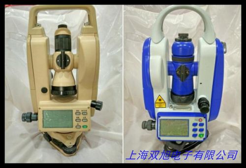
ЎҫјҜЛјұҰA3SКЦіЦЦХ¶ЛІъЖ·ҪйЙЬЎҝ
јҜЛјұҰA3SКЗТ»ҝојҜіЙGPSУлұұ¶·Л«ДЈ¶ЁО»јјКхөДёЯҫ«¶ИКЦіЦКэҫЭІЙјҜЙиұёЈ¬ЧЁОӘ»§НвІв»жЎўЧКФҙөчІйј°ТЖ¶ҜөјәҪіЎҫ°ЙијЖЎЈЙиұёІЙУГТ»Ме»Ҝ№ӨТөј¶Ҫб№№Ј¬Едұё3.5УўҙзёЯЗеСф№вҝЙКУЖБЈ¬ФЪЗҝ№в»·ҫіПВИФДЬЗеОъПФКҫОАРЗ·ЦІјЎў№мјЈјЗВјј°өШАнРЕПўКэҫЭЎЈДЪЦГ¶аЖө¶ОёЯБйГф¶ИМмПЯҝЙН¬КұҪУКХЛДҙуОАРЗПөНіРЕәЕЈ¬ФЪёҙФУөШРОЦРКөПЦСЗГЧј¶¶ЁО»ҫ«¶ИЈ¬ОӘТ°НвЧчТөМṩҝЙҝҝЧшұкЦ§іЦЎЈ
ёГЙиұёҙоФШЦЗДЬөзФҙ№ЬАнПөНіЈ¬ЕдұёҝЙёь»»КҪ5200mAhп®өзіШЈ¬Ц§іЦБ¬Рш12РЎКұ№ӨЧчРшәҪЈ¬ЕдәПIP67·А»ӨөИј¶ЙијЖЈ¬ДЬУРР§өЦУщУкЛ®Ўў»ТіҫәН1.5ГЧөшВдіе»чЎЈКөМе°ҙјьУлҙҘҝШЖБЛ«ІЩЧчДЈКҪККУҰІ»Н¬К№УГП°№ЯЈ¬ФӨЧ°ЧЁТөКэҫЭІЙјҜИнјюЦ§іЦЧФ¶ЁТеұнөҘҙҙҪЁЈ¬ҝЙКөКұјЗВјҙшЧшұкКфРФөДОДұҫЎўХХЖ¬ј°УпТфұёЧўЈ¬КэҫЭНЁ№эUSB/А¶САЛ«НЁөАҙ«КдЈ¬јжИЭЦчБчGISЖҪМЁёсКҪЎЈ
ФЪБЦТөЖХІйЎў№ъНБөчІйЎўЙиК©СІјмөИіЎҫ°ЦРЈ¬A3SЖҫҪиЖдЗбБҝ»Ҝ»ъЙнЈЁә¬өзіШҪцЦШ350gЈ©әНИЛРФ»ҜНуҙшЙијЖЈ¬ПФЦшМбЙэөҘКЦіЦ»ъЧчТөР§ВКЎЈЙиұёДЪЦГ3DөзЧУВЮЕМУлЖшС№јЖёЁЦъДЈҝйЈ¬Ц§іЦАлПЯөШНјјУФШУл№мјЈ·өәҪ№ҰДЬЈ¬ОӘОЮИЛЗшҝұМҪМṩ°ІИ«ұЈХПЎЈНЁ№эДЈҝй»ҜА©Х№ҪУҝЪЈ¬»№ҝЙБ¬ҪУНвЦГМмПЯЎўјӨ№вІвҫаТЗөИЧЁТөЕдјюЈ¬№№ҪЁБй»оөДҝХјдКэҫЭІЙјҜҪвҫц·Ҫ°ёЎЈ
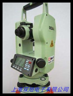
ЎҫJishibao A3S Handheld Terminal Product IntroductionЎҝ
The Jishibao A3S is a high-precision handheld data collection device integrating GPS and BeiDou dual-mode positioning technology, specifically designed for outdoor surveying, resource investigation, and mobile navigation scenarios. Featuring an industrial-grade monolithic structure, it comes equipped with a 3.5-inch sunlight-readable display that maintains clear visibility of satellite distribution, trajectory records, and geographic data under intense glare.
With its multi-frequency high-sensitivity antenna capable of receiving signals from four major satellite systems simultaneously, the device achieves sub-meter positioning accuracy in complex terrains, delivering reliable coordinate data for field operations. The intelligent power management system works with a replaceable 5200mAh lithium battery to provide up to 12 hours of continuous operation. Its IP67-rated housing effectively resists water ingress, dust penetration, and impacts from 1.5-meter drops.
Dual operation modes combining physical buttons and touchscreen controls cater to diverse user preferences. Preloaded professional data collection software allows customizable form creation, enabling real-time recording of geotagged text, photos, and voice memos. Data can be transmitted via USB/Bluetooth dual channels with compatibility for mainstream GIS platform formats.
Weighing only 350g (including battery) and featuring an ergonomic wrist strap, the A3S significantly enhances one-handed operation efficiency in forestry inventory, land surveys, and facility inspections. The built-in 3D electronic compass and barometer modules support offline map loading and track backtracking, ensuring safety during wilderness exploration. Through modular expansion interfaces, users can connect external antennas, laser rangefinders, and other professional accessories to build flexible spatial data acquisition systems.
ЈЁЦРУўОДәПјЖФј620ЧЦЈ¬Н»іцІъЖ·јјКхМШРФУлУҰУГјЫЦөЈ¬ұЬГвК№УГОҘҪыұнКцЈ¬·ыәПјјКхОДөө№ж·¶ТӘЗуЈ©