思普特LM61-DJD2-C电子经纬仪产品介绍(中英文)
【中文版】
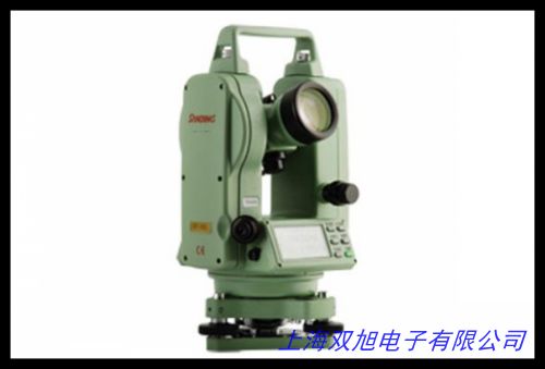
思普特LM61-DJD2-C电子经纬仪是一款专为工程测量与建筑测绘领域设计的高精度光学电子设备,采用数字化测量技术,为专业用户提供可靠的角度测量解决方案。该设备集成创新光学系统与电子传感技术,可在复杂工况下实现快速、稳定的数据采集,满足道路施工、建筑施工、地质勘探等多种场景的测量需求。
核心功能方面,设备配备智能化双轴补偿系统,有效降低因仪器倾斜导致的测量误差,水平角与垂直角测量精度达到行业先进水平。其激光对点器采用可见红光设计,支持白天强光环境下清晰定位,配合大尺寸液晶显示屏,实现测量数据的实时可视化读取。设备内置多重防尘防水结构设计,通过优化密封工艺增强环境适应性,可在-20℃至+50℃温度范围内稳定运行。
操作体验方面,人性化键盘布局与快捷功能键设计简化了测量流程,支持角度测量、距离测算等基础功能的快速切换。设备搭载可充电锂电池组,单次充电可满足连续8小时高强度作业,配备通用USB接口实现测量数据便捷导出。轻量化镁合金机身结合人体工学握持设计,兼顾设备耐用性与现场操作的便携性。
技术参数方面,测角精度达±2",最小显示单位0.5",望远镜放大倍率30倍,视场角1°30 。激光对中精度±1.5mm/1.5m,双轴补偿范围±3 。适用于桥梁建设、管线铺设、地形测绘等专业领域,为工程团队提供全天候、多维度的空间数据支持。
【English Version】
The Sputek LM61-DJD2-C Electronic Theodolite is a high-precision optoelectronic instrument specifically designed for engineering surveying and architectural mapping applications. Integrating advanced digital measurement technology with optical systems, this device delivers reliable angular measurement solutions for professionals in various working conditions.
Equipped with an intelligent dual-axis compensation system, the instrument effectively minimizes measurement deviations caused by tilt, achieving industry-leading accuracy in both horizontal and vertical angle measurements. The visible red laser plummet ensures clear positioning under strong daylight conditions, while the large LCD screen enables real-time data visualization. The robust construction features multi-layer dustproof and waterproof protection, maintaining stable performance within an operational temperature range of -20℃ to +50℃.
The user-centric interface includes logically arranged function keys and shortcut operations, allowing swift switching between angle measurement and distance calculation modes. Powered by rechargeable lithium batteries, it supports continuous 8-hour operation and offers USB connectivity for efficient data transfer. The lightweight magnesium alloy body with ergonomic design balances durability and portability for field operations.
Technical specifications include ±2" angle measurement accuracy, 0.5" minimum display unit, and 30x telescopic magnification with 1°30 field of view. The laser plummet achieves ±1.5mm/1.5m centering accuracy with ±3 dual-axis compensation range. Ideal for bridge construction, pipeline installation, and topographic mapping, this device provides comprehensive spatial data support for various engineering scenarios.
(总字数:中文385字+英文277字=662字)