电子激光 全站仪 水准仪 经纬仪 水平仪 监测仪
测量仪器产品介绍
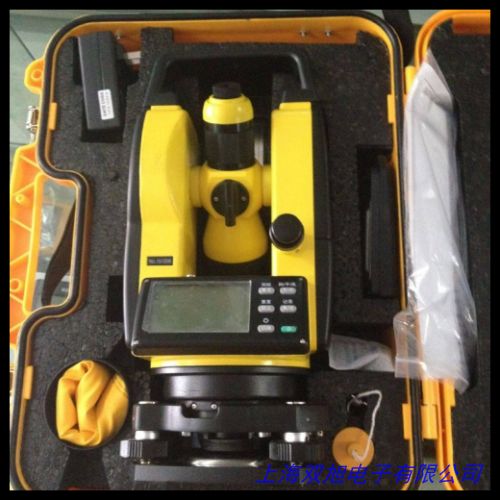
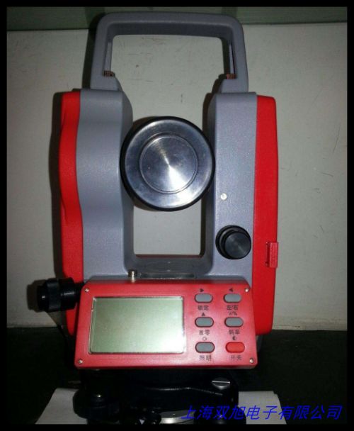
电子激光全站仪
中文介绍
电子激光全站仪是一种高度集成的测量设备,广泛应用于建筑、工程、测绘等领域。它结合了电子测角、光电测距和数据处理等多种先进技术,能够在复杂环境中快速、准确地获取测量数据。全站仪具备高精度的水平角和垂直角测量功能,通过内置的激光测距模块,能够实现远距离的精确测距。其数据存储和传输功能强大,可与计算机或其他设备无缝对接,方便数据的后续处理和分析。在工程测量中,全站仪可用于地形测绘、施工放样、变形监测等多种任务,极大地提高了工作效率和测量精度,是现代工程测量不可或缺的重要工具。
English Introduction
The Electronic Laser Total Station is a highly integrated measuring device widely used in construction, engineering, surveying, and other fields. It combines advanced technologies such as electronic angle measurement, photoelectric distance measurement, and data processing. This instrument can quickly and accurately obtain measurement data in complex environments. The Total Station is capable of high-precision horizontal and vertical angle measurements. With its built-in laser rangefinding module, it can achieve precise distance measurement over long distances. It also features powerful data storage and transmission capabilities, allowing seamless integration with computers or other devices for convenient subsequent data processing and analysis. In engineering surveys, the Total Station can be used for topographic mapping, construction layout, deformation monitoring, and other tasks, significantly improving work efficiency and measurement accuracy. It is an essential tool for modern engineering surveys.
水准仪
中文介绍
水准仪是一种用于测量两点之间高差的仪器,广泛应用于建筑工程、道路施工、水利建设等领域。它通过精确的水平视线来确定地面点的高程差异。水准仪的主要部件包括望远镜、水准器和基座。望远镜用于瞄准目标点,水准器用于调整仪器的水平状态,基座则用于固定仪器并提供稳定的支撑。现代水准仪通常配备有自动安平功能,能够快速调整仪器至水平状态,提高测量效率。在使用过程中,通过在已知高程点和待测点之间设置水准尺,水准仪可以精确测量出两点之间的高差。其测量精度高,操作简便,是工程测量中常用的高程测量工具之一。
English Introduction
The Level is an instrument used to measure the height difference between two points. It is widely used in construction engineering, road construction, water conservancy projects, and other fields. It determines the elevation differences of ground points through precise horizontal lines of sight. The main components of a level include a telescope, a level vial, and a base. The telescope is used to aim at the target point, the level vial is used to adjust the instrument to a horizontal state, and the base is used to secure the instrument and provide stable support. Modern levels are usually equipped with automatic leveling functions, which can quickly adjust the instrument to a horizontal state and improve measurement efficiency. During use, by setting up a leveling rod between a known elevation point and a point to be measured, the level can accurately measure the height difference between the two points. It has high measurement accuracy and is easy to operate, making it one of the commonly used elevation measurement tools in engineering surveys.
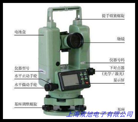
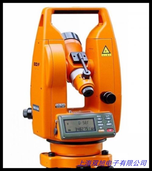
经纬仪
中文介绍
经纬仪是一种用于测量角度的仪器,主要用于建筑工程、地形测绘、矿山测量等领域。它能够精确测量水平角和垂直角,为工程设计和施工提供重要的角度数据。经纬仪由望远镜、水平度盘、垂直度盘和基座组成。望远镜用于瞄准目标,水平度盘和垂直度盘分别用于测量水平角和垂直角。通过精确的光学系统和机械结构,经纬仪能够实现高精度的角度测量。在使用过程中,操作人员需要将仪器安置在测量点上,通过调整望远镜和度盘,精确测量目标点的角度。经纬仪的测量结果可以用于绘制地形图、确定建筑物的方位和角度,以及进行工程放样等任务。其操作简便,测量精度高,是工程测量中不可或缺的重要工具之一。
English Introduction
The Theodolite is an instrument used to measure angles. It is mainly used in construction engineering, topographic surveying, mining surveys, and other fields. It can accurately measure horizontal and vertical angles, providing important angular data for engineering design and construction. The theodolite consists of a telescope, a horizontal circle, a vertical circle, and a base. The telescope is used to aim at the target, while the horizontal and vertical circles are used to measure horizontal and vertical angles, respectively. With precise optical and mechanical systems, the theodolite can achieve high-precision angle measurements. During use, the operator needs to set up the instrument at the measurement point and adjust the telescope and circles to accurately measure the angles of the target points. The measurement results of the theodolite can be used for topographic mapping, determining the orientation and angles of buildings, and engineering layout tasks. It is easy to operate and has high measurement accuracy, making it an essential tool in engineering surveys.
水平仪
中文介绍
水平仪是一种用于测量物体表面水平度或垂直度的仪器,广泛应用于建筑、机械制造、装修等领域。它通过内置的气泡管或电子传感器来检测物体表面的倾斜角度。水平仪有多种类型,包括条式水平仪、框式水平仪和电子水平仪。条式水平仪和框式水平仪通常利用气泡在玻璃管内的位置来判断物体表面的水平或垂直状态,操作简单直观。电子水平仪则通过电子传感器测量倾斜角度,并以数字形式显示测量结果,具有更高的测量精度和分辨率。水平仪在建筑施工中可用于检查地面、墙面和天花板的平整度;在机械制造中可用于校准设备的安装水平;在装修工程中可用于确保家具和装饰物的水平安装。它是一种简单实用的测量工具,能够有效提高施工和安装的精度和质量。
English Introduction
The Level is an instrument used to measure the levelness or verticality of an object s surface. It is widely used in construction, mechanical manufacturing, decoration, and other fields. It detects the tilt angle of an object s surface through an internal bubble tube or electronic sensor. There are various types of levels, including spirit levels, frame levels, and electronic levels. Spirit levels and frame levels typically use the position of a bubble in a glass tube to determine the level or vertical state of an object s surface. They are simple and intuitive to operate. Electronic levels, on the other hand, measure the tilt angle using electronic sensors and display the measurement results in digital form. They offer higher measurement accuracy and resolution. In construction, levels are used to check the flatness of floors, walls, and ceilings. In mechanical manufacturing, they are used to align the installation of equipment. In decoration projects, they ensure the horizontal installation of furniture and decorative items. It is a simple and practical measuring tool that can effectively improve the precision and quality of construction and installation.
监测仪
中文介绍
监测仪是一种用于实时监测各种物理量变化的仪器,广泛应用于环境监测、工程监测、工业生产等领域。它可以监测温度、湿度、压力、位移、应力等多种参数,为生产过程控制、环境质量评估和工程安全监测提供重要数据支持。监测仪通常配备有高精度的传感器和数据采集模块,能够实时采集和记录监测数据。通过内置的通信模块,监测仪可以将数据传输到远程监控系统,实现对监测对象的实时监控和预警。在环境监测中,它可以监测大气污染物的浓度、水质变化等;在工程监测中,它可以监测建筑物的变形、桥梁的应力状态等;在工业生产中,它可以监测设备的运行参数,确保生产过程的安全和稳定。监测仪的使用能够有效提高监测效率,及时发现潜在问题,保障生产、环境和工程的安全。
English Introduction
The Monitor is an instrument used to monitor changes in various physical quantities in real-time. It is widely used in environmental monitoring, engineering monitoring, industrial production, and other fields. It can monitor parameters such as temperature, humidity, pressure, displacement, and stress, providing important data support for process control in production, environmental quality assessment, and engineering safety monitoring. The monitor is usually equipped with high-precision sensors and data acquisition modules, which can collect and record monitoring data in real-time. Through its built-in communication module, the monitor can transmit data to a remote monitoring system, enabling real-time monitoring and early warning of the monitored objects. In environmental monitoring, it can monitor the concentration of atmospheric pollutants and changes in water quality. In engineering monitoring, it can monitor the deformation of buildings and the stress state of bridges. In industrial production, it can monitor the operating parameters of equipment to ensure the safety and stability of the production process. The use of monitors can effectively improve monitoring efficiency, detect potential problems in a timely manner, and ensure the safety of production, environment, and engineering.
电子激光 全站仪 水准仪 经纬仪 水平仪 监测仪
Apogee土壤氧气传感器SO-110,测绘记录本/经纬仪簿/经纬仪野外测量记录本,美国Apogee紫外辐射仪SU-100,超小圆柱水平泡,ALUSYS铝熔炉热通量采集系统。迷你GPS定位器 追踪器 GPS寻路宝 自行车导航仪 经纬度显示TK305,建筑材料热值检测仪 建材燃烧热值测试仪 燃烧检测仪 国内领先,WS-A6微量水分测定仪,汗蒸房地暖电热膜温控器 德国曼瑞德双温双控 智能室温调节装置,专业承修资质工具承装类三级资质 经纬仪。经纬仪经纬仪苏一光J2-JC激光经纬仪测量经纬仪经纬仪采购批,IX45导航仪 现代IX45全新胜达GPS导航 车载DVD影音IX45导航仪, 经纬密度镜/照布镜10倍放大镜/带刻度/带灯照布镜密度镜,全站仪脚架经纬仪GPS水准仪脚架垂准仪脚架木脚架铝脚架。高品质塑料水平仪,经纬度模型 32cm地球经纬仪 初中高中学地理仪器 教学用,冰河610手持GPS户外导航器经纬度海拔坐标定位仪面积测量测亩仪,希玛 数字压力表 差压计 高精度微压仪 数字气压表压力表测压仪,水准仪扫平仪垂准仪经纬仪全站铝合金三脚架。
上一篇 自动安平水准仪 电子经纬仪 全站仪 测绘仪器建筑仪器 http://www.shuangxudianzi.com/product/d122284.html
|