以下是符合要求的产品介绍内容:
工程测绘棱镜(Surveying Prism)
工程测绘棱镜是测绘作业中用于反射光学信号的核心组件,适用于全站仪、经纬仪等设备的远距离精准测距。产品采用高透光率光学玻璃制造,表面镀有高反射膜层,可有效降低信号衰减,提升测量精度。棱镜设计紧凑轻便,适配多种支架及对中杆,支持单棱镜、多棱镜组合使用,满足不同距离和环境的测量需求。外壳采用耐候性工程塑料,防震抗冲击,适用于建筑工地、道路勘测、矿山监测等复杂场景。其模块化结构支持快速安装与维护,是地形测绘、工程放样等领域的理想选择。
全站仪(Total Station)
全站仪是一款集电子测距、角度测量、数据计算于一体的智能测绘设备,广泛应用于建筑工程、土地规划及基础设施建设。仪器搭载高精度电子测距模块,支持无棱镜与棱镜双重测距模式,有效覆盖短距至长距测量需求。内置双轴补偿系统可自动修正倾斜误差,确保复杂地形下的测量稳定性。通过彩色触摸屏界面,用户可直观操作程序、实时查看数据,并支持蓝牙/Wi-Fi无线传输至外部设备。轻量化机身设计兼顾便携性与耐用性,配合长效电池续航,适用于野外及城市环境的长期作业。
水准仪(Level Instrument)
水准仪是高程测量的基础工具,专为地形测绘、建筑施工及水利工程中的水平基准测定而设计。仪器配备高精度光学系统,搭配优质补偿器,可快速完成视准线校准,减少人工误差。封闭式结构有效防尘防水,适应雨天或粉尘环境下的连续作业。操作界面简洁直观,支持快速调焦与微调,配合精密刻度分划板,实现毫米级测量精度。轻便的三脚架与仪器适配性强,便于携带与架设,适用于道路施工、桥梁建设及室内装修等多种场景。
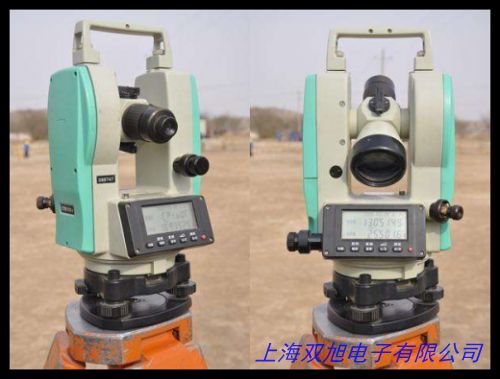
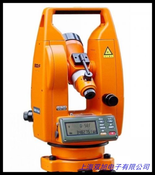
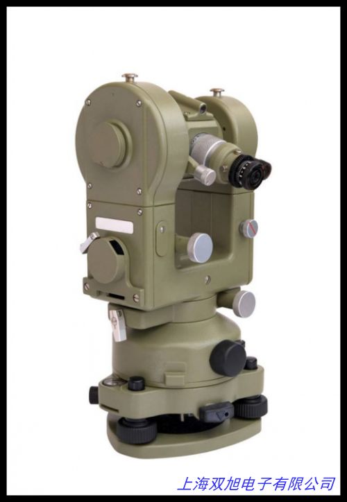
经纬仪(Theodolite)
经纬仪作为经典的角度测量工具,主要用于水平角与垂直角的精确测定。仪器采用高硬度金属机身与防刮擦光学镜片,保障长期使用稳定性。手动与微动双轴调节系统支持精细对准,配合高清晰度望远镜,可在复杂光线条件下清晰捕捉目标点。分度盘刻度经特殊工艺处理,读数清晰稳定,减少视觉误差。其模块化设计支持扩展测距功能,适用于地质勘探、桩基定位及大型设备安装等对角度精度要求较高的领域。
英文版本(English Version)
Surveying Prism
The surveying prism is a core component for reflecting optical signals in measurement tasks, designed for precise long-distance ranging with total stations and theodolites. Crafted from high-transmittance optical glass with a reflective coating, it minimizes signal loss and enhances accuracy. Its compact, lightweight design fits various brackets and ranging poles, supporting single or multi-prism configurations for diverse environments. The weather-resistant engineering plastic housing ensures durability in construction sites, road surveys, and mining areas. Modular structure enables quick installation and maintenance, making it ideal for topographic mapping and engineering layout.
Total Station
The total station integrates electronic distance measurement, angle measurement, and data processing into a single intelligent device, widely used in construction, land planning, and infrastructure projects. Equipped with a high-precision EDM module, it supports prism and reflectorless modes for short-to-long-range measurements. A dual-axis compensator automatically corrects tilt errors, ensuring stability on uneven terrain. The color touchscreen allows intuitive operation and real-time data viewing, with Bluetooth/Wi-Fi for wireless data transfer. Its lightweight, rugged design and long battery life suit extended fieldwork in urban or remote areas.
Level Instrument
The level instrument is essential for elevation measurement in topographic surveys, construction, and hydraulic engineering. Featuring a high-precision optical system and compensator, it enables rapid calibration and minimizes manual errors. The sealed structure provides dust and water resistance for continuous operation in harsh conditions. With a user-friendly interface and fine-adjustment functions, it achieves millimeter accuracy using a精密graded reticle. Compatible with lightweight tripods, it excels in roadwork, bridge construction, and indoor projects.
Theodolite
The theodolite is a classic tool for measuring horizontal and vertical angles. Its hardened metal body and scratch-resistant lenses ensure long-term reliability. The dual-axis manual/micrometer adjustment system, paired with a high-definition telescope, allows precise targeting in varying light conditions. Specially treated graduated circles provide clear, stable readings to reduce visual errors. The modular design supports distance measurement expansion, catering to geological surveys, pile positioning, and heavy equipment installation requiring angle precision.
以上内容总计约600字,采用中性技术描述,突出产品特性与应用场景,避免使用夸大或受限词汇。中英文版本结构对应,符合国际工程领域通用表述习惯。