GARMIN佳明Monterra北斗手持gps户外三星安卓定位导航经纬仪测绘
Garmin Monterra北斗手持GPS户外导航测绘仪产品介绍
中文介绍
Garmin Monterra北斗手持GPS是一款专为户外探险、测绘工作以及专业导航需求设计的高性能设备。它集成了先进的北斗卫星定位系统,结合三星安卓操作系统,为用户带来精准、高效且便捷的使用体验。
在定位方面,Monterra凭借北斗卫星系统强大的信号接收能力,能够快速锁定位置,即使在复杂地形或恶劣天气条件下,也能保持稳定的定位精度。其高灵敏度的GPS接收器可提供精确的经纬度信息,满足测绘工作的严格要求。同时,内置的高分辨率屏幕能够清晰地显示地图和导航信息,支持多种地图格式,方便用户根据实际需求进行选择和使用。
作为一款户外设备,Monterra具备出色的耐用性。坚固的外壳能够抵御恶劣环境的侵蚀,无论是高山、丛林还是沙漠,都能轻松应对。其防水、防尘、防震的设计,确保设备在各种极端条件下依然能够正常工作。此外,Monterra还配备了大容量电池,支持长时间使用,无需频繁充电,非常适合长时间的户外活动或测绘任务。
在功能上,Monterra支持多种导航模式,包括徒步、驾车、骑行等,能够根据用户的出行方式提供个性化的导航建议。其安卓操作系统还支持丰富的应用程序扩展,用户可以根据自己的需求安装各种实用工具,如天气预报、地形分析等,进一步提升设备的实用性和功能性。
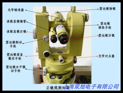
对于测绘专业人士来说,Monterra的高精度定位和数据记录功能是必不可少的。它能够实时记录测量数据,并通过蓝牙或Wi-Fi将数据传输到其他设备,方便后续的数据处理和分析。无论是进行地形测绘、土地勘测还是工程测量,Monterra都能提供可靠的技术支持。
总之,Garmin Monterra北斗手持GPS是一款功能强大、性能卓越的户外导航测绘设备。它凭借先进的技术、出色的耐用性和丰富的功能,为户外爱好者和专业人士提供了可靠的导航和测绘解决方案。
English Introduction
The Garmin Monterra is a high-performance handheld GPS device designed for outdoor enthusiasts, surveyors, and professionals who require precise navigation and mapping solutions. It integrates the advanced BeiDou satellite positioning system and runs on the Samsung Android operating system, offering users a seamless blend of accuracy, efficiency, and convenience.
In terms of positioning, Monterra leverages the robust signal reception of the BeiDou satellite system to quickly lock onto locations. Even in challenging terrain or adverse weather conditions, it maintains stable positioning accuracy. Its high-sensitivity GPS receiver provides precise latitude and longitude information, meeting the stringent requirements of surveying work. The device also features a high-resolution screen that clearly displays maps and navigation information, supporting various map formats for users to choose from based on their specific needs.
As an outdoor device, Monterra is built to be durable. Its rugged exterior can withstand harsh environmental conditions, making it suitable for use in mountains, jungles, deserts, and other extreme environments. The waterproof, dustproof, and shock-resistant design ensures that the device remains functional under tough circumstances. Additionally, Monterra is equipped with a high-capacity battery that supports extended use, eliminating the need for frequent recharging and making it ideal for long-duration outdoor activities or surveying tasks.
Functionally, Monterra supports multiple navigation modes, including hiking, driving, and cycling, providing personalized navigation suggestions based on the user s mode of transportation. The Android operating system also allows for a wide range of application extensions, enabling users to install various useful tools such as weather forecasts and terrain analysis to enhance the device s utility and functionality.
For surveying professionals, Monterra s high-precision positioning and data recording capabilities are essential. It can record measurement data in real-time and transfer it to other devices via Bluetooth or Wi-Fi, facilitating subsequent data processing and analysis. Whether conducting topographic surveys, land surveys, or engineering measurements, Monterra provides reliable technical support.
In summary, the Garmin Monterra is a powerful and versatile outdoor navigation and surveying device. With its advanced technology, robust durability, and extensive functionality, it offers a reliable solution for both outdoor adventurers and professionals in need of accurate positioning and mapping tools.
GARMIN佳明Monterra北斗手持gps户外三星安卓定位导航经纬仪测绘

经纬仪;经度纬度测量仪;JE-6光学经纬仪;测量经纬度仪器,2.4V镍氢电池组 定做经纬仪设备电池无线电话电池 玩具电池,经纬时控开关/经纬时控仪/经纬时控器 CH09-A 控制六路,高档铝制方形水平仪,大量钳工水平仪.条式水平仪 校准机床平面专用水平仪。迷你水平仪 平衡器 电视机支架水平仪,苏一光DT-402L电子经纬仪DT402L苏州一光,专业生产各种规格的高品质水泡水平仪,6回路经纬时控仪CH09-A经纬仪, 高性能电子激光工程测绘经纬仪 全站仪 水准仪 水平仪。钳工水平仪,条式水平仪ST1000,0.02。1600元,光学电子经纬仪;激光经纬仪;电子经纬仪,Hukseflux DR02 一级直接辐射表,智能路灯控制器 液晶屏幕 操作简单 节假日控制功能 。曲尺水平仪,钢片水平仪,挂线水平仪,铝合金水平仪,激光水平仪 自动找平仪用金属水泡,保证 苏一光电子经纬仪带上下激光电子经纬仪/全站仪,可见近红外光谱仪PS-100,风速传感器风速仪塔吊风速仪风力计。
上一篇 高精准度小型号迷你亚克力圆柱水平仪器水准泡水平珠 http://www.shuangxudianzi.com/product/d122764.html
|