��;�ֳ�N300 �ֳ�GPS/GIS���ݲɼ��� ��Ķ�ǵ����Ǿ�γ�Ȳ�����
��Ʒ����
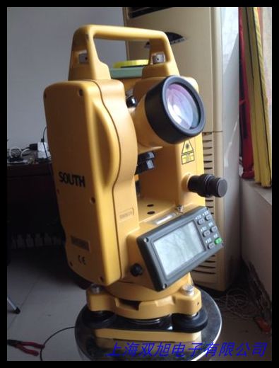
��;N300��һ��רΪ��ҵ�û���Ƶĸ߾����ֳ�GPS/GIS���ݲɼ��豸����߲�Ķ�Ǻ͵����ǹ��ܡ���Ϊ���õ����ǵ�������Ʒ��������20ͨ������GPSģ�飨L1��C/A�룩�����㶨λ���ȿɴ�3-5�ף����SBAS��ּ�����������1-3�ף�����Ұ����ҵ�ľ�����2.2Ӣ�繤ҵ�����������ǿ������Ȼ�����ɼ���������幤ѧ��ƣ�ʵ�ֵ��ֲ����ı���ԡ�����ȫ��������ͼ��֧��WGS84������54������80�ȶ�������ϵͳ����ʵʱ��ȡ���ꡢ�ܳ�����������ݣ�������Google Earth���ݸ�ʽ����shp��mif��dxf�ȣ���������GISƽ̨���νӡ�1613
������
�豸֧�������������ģʽ��ʵʱ��¼�����ߺͱ��溽�������ر�����й��û������ṩ"Ķ"��λ��ʾ�����ݲɼ����̼���Ч���ɴ洢3000�����㡢50��������ÿ��5000�㣩��60�����ߣ�ÿ��100�㣩���䱸ר��﮵�ؿ���������25Сʱ������USB���ص�Դ���磬IPX7����ˮ��1.5�����������Ӧ���ֶ��ӻ��������õ������̡���ѹ��ƺ��¶ȴ���������չ�˻���Ӧ�ó���������������105�ˣ�������أ����ߴ�Ϊ120×57×30���ף���Я��ͻ����21119
��������
��;N300����ȫ���������GPS���ߣ�����������2�룬1Hz������ȷ����̬���ݵ�ʵʱ�ԡ���ҵ��������ͨ�����ط�������������ʱ���ճֲ���ƣ�͡��ڴ�֧��128MB�洢����ͨ��MicroSD����չ��4GB�����ص����ݲɼ�ƽ��������Ч��������ȷ�ԣ���NMEA0183����Э�鱣�����豸�����ԡ���������������̿�ʵ��PC�����ݹ�����֧�ֺ��߹滮������ת����6814
Ӧ�ó���
����Ʒ�㷺Ӧ����ũ�ֿ��顢���ز�桢����Ѳ�켰Ұ����Դ�������������������복�ز���ģʽ�ر��ʺϸ��ӵ�����ҵ��587���POI�����ͼ��ԴΪ�����ṩ�ɿ��ο�������ͨ�����豸��ȣ�N300�����ݴ���Ч�ʣ�֧��CSV������������ϵͳ�ȶ��ԣ������¶�-20��~60�棩��������������ƣ���רҵ�û����Լ۱�֮ѡ��31322
English Version
Product Overview
The ColorTrip N300 is a professional handheld GPS/GIS data collector with surveying and navigation capabilities. Equipped with a 20-channel parallel GPS module (L1, C/A code), it achieves 3-5m standalone positioning accuracy, enhanced to 1-3m with SBAS differential technology. The 2.2" industrial-grade color LCD ensures clear visibility under strong sunlight, while ergonomic design enables one-hand operation. Preloaded with nationwide base maps, it supports WGS84, Beijing 54, Xi an 80 coordinate systems and exports data in multiple formats (shp, mif, dxf) compatible with Google Earth. 1623
Key Features
Three area measurement modes (real-time tracking, route-based, and saved track) are provided, featuring "mu" unit display for Chinese users. It stores 3,000 waypoints, 50 tracks (5,000 points each), and 60 routes (100 points each). The lithium battery offers 25-hour continuous operation with USB/car charger support. IPX7 waterproof rating and 1.5m drop resistance withstand harsh environments. Built-in sensors include e-compass, barometric altimeter, and thermometer. At 105g (excluding battery) and 120×57×30mm, it excels in portability. 21119
Technical Advantages
The omnidirectional high-sensitivity antenna enables 2-second hot start and 1Hz update rate. Industrial-grade housing with anti-slip texture reduces fatigue during prolonged use. The 128MB internal memory is expandable to 4GB via MicroSD. Unique data averaging function improves measurement accuracy, while NMEA0183 protocol ensures device compatibility. Bundled PC software facilitates data management and coordinate conversion. 6814
Applications
Ideal for forestry surveys, land mapping, power line inspections, and field research. Slope/carrier measurement modes adapt to complex terrains, with 5.87 million POIs enhancing navigation. Compared to consumer devices, N300 offers superior data processing (CSV batch export) and system stability (-20��~60�� operating range), making it a cost-effective tool for professionals. 31322
��;�ֳ�N300 �ֳ�GPS/GIS���ݲɼ��� ��Ķ�ǵ����Ǿ�γ�Ȳ�����
ǯ��ר�ÿ�ʽˮƽ��|��ʽˮƽ��|150-300mm|����ˮƽ��|�ʱ�һ�꣬���Ӿ�γ�ǣ��¹�Sommer SPA��ѩ���Է����ǣ�OWV-300 TM ��ѧ���ܼ��ȴ�����������R.M.YOUNG ����ʾ��06201/06201H��רҵ�������ֹ��ĸ�Ʒ��ˮ��ˮƽ�ǣ�����ˮƽ�� ����ˮƽ�ǣ��л�����ˮ�� ˮƽ�� ����ˮ�� ˮƽ�� ˮ�� ����Բˮ�ݣ�garmin����gps 72h�ֳ�gps�����Ǻ������ǵ�����γ�����굼��Ư��������ˮƽ�� ������ˮƽ�ǡ�Ϋ����ѧ����ˮƽ�Ǻ���ˮƽ�Ǹ���ˮƽ���ͺ�ȫ��LT402L���¼�����Ӿ�γ�ǣ�MetOne 010C������ٴ�����020C����������֯����SFY241/��γ�ܶȾ�/γ�ܾ�/�ܶȳ�-���ơ�a��ʽˮƽ�� ��ˮ��ǯ��ˮƽ�� �����豸����ˮƽ�Ǿ���0.02�� ����Ӧ��γʱ���ǵ�·����ר�ã�X28�����ֳ�GPS��λ�Ǿ�γ�����ǵ����Ǵ������꺣�β���������MPS-2����ˮ�Ƽ��ϵͳ����CSI Campbell���߾����л�����ˮ�ݣ�ˮƽ�ݣ�ˮƽ��ͼ��
��һƪ ������CPC DELUXE1100HD������Զ������߱�ר�Զ�Ѱ�������� http://www.shuangxudianzi.com/product/d122409.html
|