彩途k20b徒步户外GPS定位仪经纬度坐标测量仪 海拔定位仪 测亩仪
彩途K20B徒步户外GPS定位仪产品介绍(中英文)
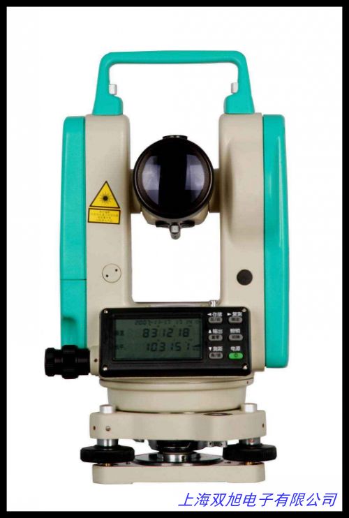
彩途K20B是一款专为徒步户外活动设计的专业级GPS定位设备,集经纬度坐标测量、海拔定位和土地面积测量功能于一体。该设备采用北斗与GPS双星定位系统,确保在复杂环境中快速锁定位置,定位精度可达1米级别。配备2.2英寸半反半透彩色显示屏,阳光下清晰可见,画面细腻;支持锂电池与AA电池双供电模式,满足野外长时间使用需求。内置全国地图架构,兼容用户自定义矢量地图、等高线地图及卫星影像,支持轨迹记录、坐标双显、电子罗盘等实用功能。三防设计(防尘、防摔、防水)使其适应各类户外场景,重量轻巧便于携带。此外,设备内置气压高度计和温度传感器,可实时测量海拔及环境数据,并具备土地面积测算功能,适用于农业普查、林业调查等专业领域。125
The Caitu K20B is a professional-grade GPS device designed for hiking and outdoor activities, integrating longitude/latitude coordinate measurement, altitude positioning, and land area calculation. Equipped with BeiDou and GPS dual-satellite positioning systems, it ensures rapid location locking in complex environments with positioning accuracy up to 1-meter level. The 2.2-inch semi-transflective color screen provides clear visibility under sunlight with细腻display. It supports dual power modes (lithium battery and AA batteries) for extended field use. The built-in national map framework accommodates user-customized vector maps, contour maps, and satellite imagery, while offering practical features like track recording, dual-coordinate display, and electronic compass. Its rugged design (dustproof, shockproof, waterproof) adapts to various outdoor scenarios, and the lightweight body ensures portability. Additionally, the built-in barometric altimeter and temperature sensor enable real-time altitude/environmental data measurement, along with land area calculation suitable for agricultural surveys and forestry applications. 92122
核心功能与技术特点(中英文)
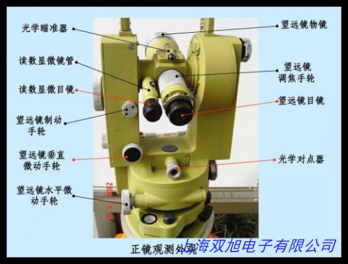
设备采用开放地图架构,允许用户自由导入多种格式地图数据,如栅格地图和卫星影像。其48通道高性能GPS模块支持SBAS差分技术,实时定位精度提升至2米内。独特的电源管理技术显著延长续航,锂电池模式下可连续工作15小时。配备三轴电子罗盘、气压计和G-Sensor传感器,实现多维环境数据采集。测亩功能支持不规则地块面积计算,测量结果可直接导出至管理软件。工业级材料外壳通过1.5米跌落测试,IPX7防水等级适应雨雪天气操作。51628
The device adopts an open map architecture, allowing users to import diverse map data formats including raster maps and satellite imagery. Its 48-channel high-performance GPS module supports SBAS differential technology, enhancing real-time positioning accuracy within 2 meters. Unique power management technology extends battery life up to 15 hours in lithium mode. Equipped with 3-axis electronic compass, barometer and G-Sensor, it enables multi-dimensional environmental data collection. The land measurement function supports irregular plot area calculation with exportable results to management software. The industrial-grade casing passes 1.5-meter drop tests and IPX7 waterproof rating ensures operation in rain/snow conditions. 61417
应用场景与用户体验(中英文)
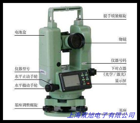
适用于徒步探险、地质勘探、农业测绘等场景。用户反馈其按键操作设计符合野外使用习惯,抗干扰性强;坐标双显界面可同时展示经纬度与平面坐标,便于不同场景切换。MicroSD卡槽支持32GB扩展存储大量轨迹数据,USB接口实现快速数据传输。屏幕分辨率240×320呈现细腻地图细节,65K色显示优化了等高线辨识度。随附挂绳、车载支架等配件提升使用便捷性,满足户外工作者对轻量化、高可靠性设备的需求。71118
Ideal for hiking expeditions, geological surveys, and agricultural mapping. User feedback highlights its button design tailored for field operation with strong anti-interference capability. The dual-coordinate interface simultaneously displays longitude/latitude and plane coordinates for scenario switching. The MicroSD slot supports 32GB expansion for massive track storage, while USB enables fast data transfer. The 240×320 screen resolution delivers detailed map rendering with 65K colors optimizing contour line recognition. Included accessories like lanyards and car mounts enhance usability, meeting outdoor professionals demands for lightweight yet reliable equipment. 81219
彩途k20b徒步户外GPS定位仪经纬度坐标测量仪 海拔定位仪 测亩仪
JW-180型 阴极铁碳压降专用检测仪 高效率测定,昌汇 全套各线数经纬密度镜纬密镜面料密度镜 64,41,80,120,彩途k20b徒步户外GPS定位仪经纬度坐标测量仪 海拔定位仪 测亩仪,电子经纬仪,换纬装置,纬纱装置,准直经纬仪技术原理结构图纸专题技术辑。肇庆四会三水江门鹤山南海 维修全站仪经纬仪自动安平水准仪,经纬密度镜 上海第十二丝织厂制 沪00000380玻璃材质一套四块,测杆 红白测杆 测量花杆 铝合金测量花杆 经纬仪花杆,光纤旋转连接器光纤滑环用于光电经纬仪以及物料传输系统,测变压汽油专用气相色谱仪。/各种规格金属万向水准器,长75mm挂线水平仪水平泡 测水平仪水准泡,2秒自准直经纬仪 型号:TDJ2Z,CX30导航仪 长安CX30专车专用GPS导航仪 车载DVD影音CX30导航仪。科利达电子经纬仪KC-10充电器 适用于科利达DT02/05 KT020系列,钻石牌奥科经纬打样刀片鞋样切割刀服装CAD绘图仪平板立式切割机,相框水平仪圆柱水准泡安装 水平珠 10*35圆柱水平泡 相框墙配件,经纬度模型 科毅 32cm地球经纬仪 初中高中学地理仪器,垂准仪激光靶 经纬仪水准仪反射靶15 20 30CM 红色透明 透明白色。
上一篇 迷你水平仪 笔型水平仪 http://www.shuangxudianzi.com/product/d122529.html
|