ЁОGarmin eTrex 209X GPSЪжГжВтЛцЩшБИ жагЂЮФВњЦЗНщЩмЁП
---жаЮФАц---
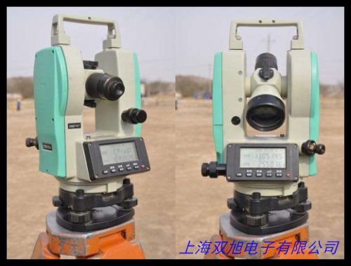
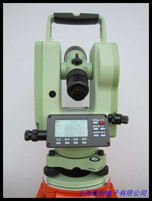
Garmin eTrex 209X GPSЪжГжаавЕАцЪЧвЛПюзЈЮЊЛЇЭтВтЛцгыЪ§ОнВЩМЏЩшМЦЕФИпадФмЩшБИЃЌМцЙЫЪЕгУадгыПЩППадЃЌЪЪгУгкЭСЕиВтСПЁЂзЪдДПБВщЁЂЙЄГЬЙцЛЎЕШЖржжзЈвЕГЁОАЁЃЩшБИВЩгУМсЙЬФЭгУЕФЙЄГЬНсЙЙЃЌДюХфИпСщУєЖШЖрЮРаЧЯЕЭГНгЪеФЃПщЃЌдкИДдгЕиаЮжавРШЛФмЮШЖЈЛёШЁЖЈЮЛаХЯЂЁЃ
КЫаФЙІФмЗНУцЃЌeTrex 209XжЇГжОЋзМОЮГЖШзјБъВЩМЏЃЌЮѓВюЗЖЮЇгХЛЏжСаавЕЪЕгУМЖБ№ЁЃЦфУцЛ§ВтСПЙІФмПЩЭЈЙ§ЙьМЃМЧТМздЖЏМЦЫуЗтБеЧјгђЪ§жЕЃЌЪЪгУгкХЉЬяЙцЛЎЁЂЩСжзЪдДЭГМЦЕШашвЊПьЫйЙРЫуЕФГЁОАЁЃЩшБИДюди2.2гЂДчПЙЗДЩфбєЙтЦСЃЌЧПЙтЛЗОГЯТШдФмЧхЮњЯдЪОЕиЭМЙьМЃгыЙиМќЪ§ОнЃЌХфКЯЪЕЬхАДМќЩшМЦЃЌМДЪЙХхДїЪжЬзвВПЩЧсЫЩВйзїЁЃ
дкгВМўХфжУЩЯЃЌЩшБИФкжУПЩИќЛЛAAЕчГиЙЉЕчЯЕЭГЃЌжЇГжГЄДя18аЁЪБСЌајзївЕЃЌТњзуШЋЬьКђвАЭтЪЙгУашЧѓЁЃIPX7ЗРЫЎЕШМЖШЗБЃдкгъбЉЛђГБЪЊЛЗОГжаЮШЖЈдЫааЃЌЗРе№ЭтПЧЩшМЦПЩГаЪм1.5УзЕјТфГхЛїЁЃЭЌЪБЃЌЩшБИжЇГжWGS84ЁЂББОЉ54ЕШЖржжзјБъЯЕЭГЧаЛЛЃЌМцШнжїСїВтЛцШэМўЪ§ОнИёЪНЃЌБугкКѓЦкЪ§ОнДІРэгыГЩЙћЪфГіЁЃ
еыЖдаавЕгУЛЇашЧѓЃЌeTrex 209XЬсЙЉзЈвЕАцЕиЭМЙмРэЙЄОпЃЌгУЛЇПЩздЖЈвхКНЕуБъМЧЁЂЙьМЃбеЩЋМАЪ§ОнзжЖЮЁЃЭЈЙ§USBЛђРЖбРСЌНгЃЌПЩПьЫйЕМГіKMLЁЂGPXЕШИёЪНЮФМўЃЌгыPCЖЫЛђвЦЖЏЖЫЦНЬЈЮоЗьЖдНгЁЃДЫЭтЃЌЩшБИжЇГжКНМЃЗЕКНЙІФмЃЌдкЮоЭјТчЛЗОГЯТШдФмЮЊзївЕШЫдБЬсЙЉТЗОЖжИв§ЁЃ
ЮоТлЪЧХЉвЕгУЕиЙцЛЎЁЂЛЇЭтЕижЪПМВьЃЌЛЙЪЧЛљДЁЩшЪЉНЈЩшЕФЯжГЁЬЄПБЃЌeTrex 209XвдЦфжБЙлЕФВйзїТпМгыЮШЖЈЕФЪ§ОнБэЯжЃЌГЩЮЊзЈвЕЭХЖгЕФИпаЇзївЕЛяАщЁЃЩшБИМцЙЫЧсСПЛЏЩшМЦгыРЉеЙадФмЃЌБъХфЙвЩўПзгыБГМаЃЌЪЪХфГЕдижЇМмЛђШ§НХМмЕШЖржжАВзАЗНЪНЁЃ
---English Version---
The Garmin eTrex 209X GPS Handheld Mapper is a professional-grade tool engineered for precision field data collection, offering robust performance for land surveying, environmental monitoring, and engineering applications. Built with a ruggedized housing, this device integrates multi-constellation satellite tracking to maintain stable positioning even in challenging environments.
Equipped with enhanced coordinate acquisition capabilities, the eTrex 209X delivers optimized location accuracy for practical field requirements. Its area calculation function automatically measures enclosed spaces by recording movement trajectories, ideal for agricultural land assessment and natural resource management. The 2.2-inch sunlight-readable display ensures clear visibility of mapping data under direct sunlight, while tactile buttons allow reliable operation with gloves.
Powered by replaceable AA batteries, the device provides up to 18 hours of continuous operation. With IPX7 water resistance and 1.5-meter drop resistance, it withstands harsh weather conditions and accidental impacts. The system supports coordinate transformations between WGS84, Beijing 54, and other common standards, ensuring compatibility with GIS software for streamlined data processing.
Professionals will appreciate the customizable mapping toolkit, allowing personalized waypoint symbols, track colors, and data fields. Data can be exported via USB or Bluetooth in KML/GPX formats for seamless integration with desktop and mobile platforms. The trackback feature provides reliable navigation guidance in offline environments.
Weighing under 200g with mounting accessories, the eTrex 209X adapts to vehicle dashboards, tripods, or handheld use. Its intuitive interface and reliable performance make it an essential tool for field surveys, geological explorations, and infrastructure planning teams seeking efficient data collection solutions.
ЃЈзмзжЪ§ЃКжаЮФ426зж + гЂЮФ389зжЃЉ